- INFORMATION
COMS
-

-
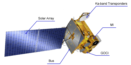
- - Korea’s first geostationary multi-purpose satellite which is stationed at an altitude of 36,000 km above the Earth’s equator and at a longitude of 128.2°E performing the duties of meteorological and ocean observations and communications services
- - A joint project that started in 2003 by the KMA (Korea Meteorological Administration), MEST (Ministry of Education, Science & Technology), MLTM (Ministry of Land, Transport and Maritime Affairs), and KCC (Korea Communications Commission) in accordance with the Mid and Long-term National Space Development Plan
- - Korea Aerospace Research Institute is the project leader and responsible for the overall development. EDAS Astrium of France and ITT of the United States are the foreign partners involved.
- - Launched successfully from the Guiana Space Center, Kourou in French Guiana, South America on June 27, 2010
-
-

-
- - Dimensions: 2.2 × 2.4 × 2.6m
- - Mass at launch: 2.5 tons
- - Operational life: 7 years
- - Manufactured by: KARI (Korea Aerospace Research Institute) and EADS Astrium of France
-

-

-
- - Received meteorological satellite data from Japan and other countries every 30 minutes
- - Observation areas and observation times could not be adjusted Forecasts based on simple image analysis were possible
-

-
- - The operation of our own meteorological satellite made intensive monitoring of extreme weather conditions possible through observing over the Korean peninsula with maximum 8-minute interval.
- - In case of an extreme weather situation, it is possible to adjust independently the observation areas and times around the Korean peninsula.
- - It is possible to generate data to support image analysis, our own data processing systems, and a numerical forecast.
-

-

-
- - Continuous monitoring of imagery and extracting of meteorological products
- - Early detection of severe weather phenomena
- - Monitoring of climate change and atmospheric environment
-

<Sample images of 5 channels of the COMS meteorological imager> -

-
- - Monitoring of marine environment and marine ecology of seas surrounding the Korean peninsula
- - Generation of chlorophylls production estimates and fishery information
-
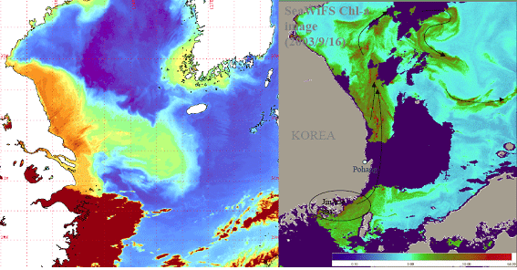
<Oceans monitoring mission of COMS: (L) Analysis of the turbid water off Chinese coasts (R) Analysis of the movements of red tides off the East Coast> -

-
- - Broadband satellite multimedia testing services
- - Korean Ka-band Transponders space certification
-
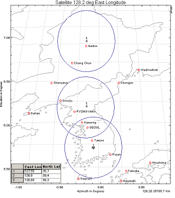
<Service areas of communications repeater of COMS>
-

-

-
- - It has the same performance characteristics as the meteorological sensors mounted on GOES-8 ~ 13 of the U.S. and MTSAT-2 of Japan.
-

-
Basic Performance Data Number of Channels 5 channels (1 visible, 4 infrared) Observation Period Less than 27 minutes Each Channels Data Channels Wavelength(㎛) Spatial Resolution Applications Visible 0.67 1Km Weekly cloud images, Asian dust, forest fires, fog observation, atmospheric motion vector Shortwave infrared 3.7 4Km Night fog & low-level clouds, forest fire detection, land surface temperature Water vapor 6.7 4Km Observation of mid and upper atmospheric humidity & upper atmospheric motions Infrared 1 10.8 4Km Cloud information, sea surface temperature, Asian dust observation Infrared 2 12.0 4Km Cloud information, sea surface temperature, Asian dust observation - - 24-hr continuous monitoring of weather changes along with securing Korea’s first 24-hr continuous observation by infrared channels
-

-
- - Generation of 16 types of analysis data using the L1B data of COMS
- - Data used in weather forecasting & numerical forecasting input data, prediction of climate changes
- - Meteorological Data Processing System calculates meteorological elements
-
CMDPS Development Computation Sources Contents Applications Cloud detection Presence of clouds information Weather and numerical forecast Clear sky radiance Estimation of radiation level in cloud-free region Weather and numerical forecast Atmospheric motion vector Trace movement path of water vapor Numerical forecast Sea surface temperature Sea surface temperature Numerical forecast & climate monitoring, ocean Land surface temperature Land surface temperatures of regions in East Asia Numerical forecast & climate monitoring Sea Ice/Snow detection Estimate sea ice & snow covered regions Numerical forecast & climate monitoring, Asian dust prediction Insolation Solar energy reaching the ground Agricultural meteorology, climate research Upper tropospheric humidity Vapor amount in the upper troposphere Numerical forecast & climate monitoring Total precipitable water Total vapor amount in troposphere Numerical forecast & climate monitoring Cloud analysis Estimation of shapes & amount of clouds & characteristics of cloud particles Numerical forecast & climate monitoring Cloud top temperatures & heights Estimate the temperatures & heights at the cloud tops Numerical forecast & climate monitoring Fog Fog detection by separating low cloud and fog Aviation meteorology Rainfall intensity Rainfall intensity depending on the types of clouds Weather and numerical forecast Outgoing long-wave radiation Estimation of earth’s long-wave radiation at the top of the atmosphere Numerical forecast & climate monitoring Aerosol index Observation of Asian dust in the atmosphere Asian dust forecast & environment monitoring Aerosol optical depth Estimation of atmospheric turbidity due to aerosol Asian dust forecast, environment monitoring, & climate research -
<Concepts of CMDPS>
meteorological imager
The meteorological imager is composed of a sensor module that performs the actual meteorological observations, a power module that supplies stable power to the meteorological imager after proper modulation of the power the satellite receives, and a electronic module that is responsible for the control of the sensor module as well as the various electrical signals exchanged and the power connection between the meteorological imager and the satellite.

-
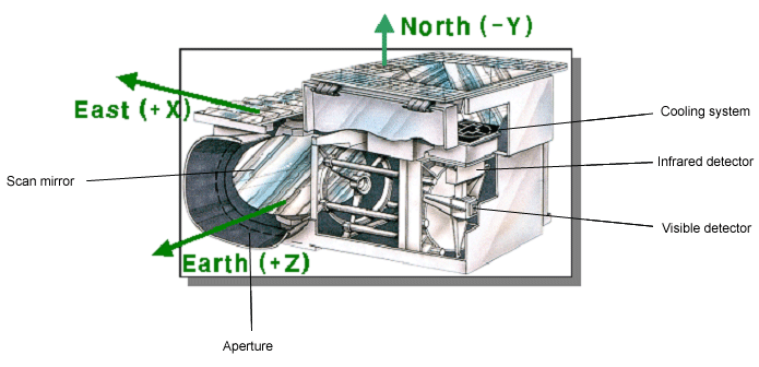
- - Scan mirror: Allows observations of user’s points of interest
- - Aperture: Gathers the light that reaches the scan mirror
- - Spectroscope: Sorts the incoming radiation through the telescope according to wavelengths
- - Detector: Converts radiant energy into electrical energy
- - Black body: Black body used to secure the performance of infrared radiant energy
- - Cooling system: Responsible for maintaining the sensor temperature at a cryogenic level
-
<Configuration of the sensor module of the meteorological imager> -
Meteorological imager specifications Bus dimensions 2.4m × 2.4m × 2.6m Mass at launch 2,500 kg Operational life 7 years Meteorological sensor 5-channel imager (1 visible, 4 infrared) For each Channel specifications Channel Center wavelength (㎛) Wavelength range (㎛) Spatial resolution (km) Visible 0.675 0.55~0.8 1 Shortwave infrared 3.75 3.5~4.0 4 Water vapor 6.75 6.5~7.0 4 Infrared 1 10.8 10.3~11.3 4 Infrared 2 12.0 11.5~12.5 4

-
- The meteorological imager receives commands from the ground and then makes observations of the requested areas by moving the scan mirror in East/West and North/South directions. The radiant energy collected through the aperture first passes through the main and secondary apertures, is sorted according to wavelengths in the spectroscope, and is then sent to the detector: see the diagram below.
-
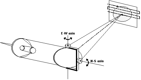
<The radiant energy flow after passing the scan mirror> -
- The radiant energy observed and entered into a telescope is distinguished by channel in the manner presented in the following picture and detected by each detector.
-
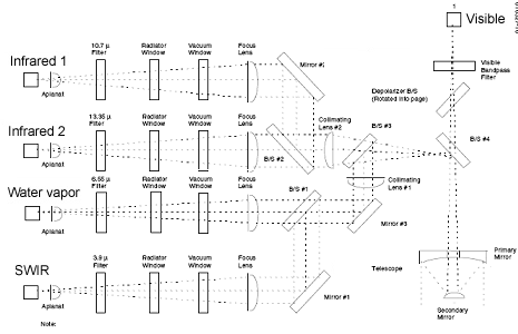
<Radiant energy of the channel category>

-
- - The meteorological imager’s detectors store the observed energy in the form of photon energy. The electric energy is then boosted and expressed in voltage and current according to the potential difference.
- - In COMS, the visible channel detector uses the semiconductor material silicon (Si.), shortwave infrared channel detector indium antimonide (InSb), and the remaining channel detectors HgCdTe (MCT) that are commonly used in infrared detectors.
- - The Infrared detector is sensitive to low temperatures so a cooler is required to remove the surrounding heat sources.


-
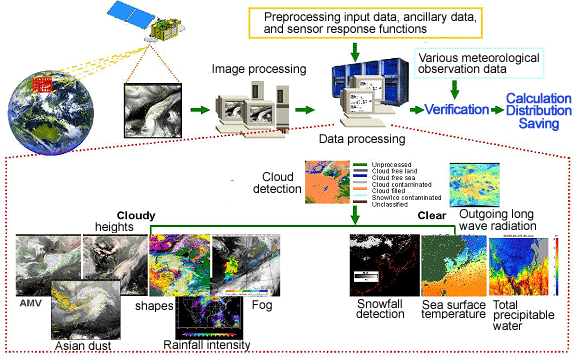
- - The COMS transmits observed satellite data to Earth in the form of Windband data.
- - The data transmitted to Earth, after having gone through location and radiation verification processes, is provided as image data and processed using the meteorological data processing system to produce output including Asian dust, fog, and sea surface temperature.
- - The image data and output are reprocessed with other data such as numerical forecasting data and oceanographic observation data, and others to produce a data package complying with international standards for satellite information, LRIT/HRIT. The data package is retransmitted to the satellite to be distributed to users worldwide.

-
- - The satellite, in addition to the observed data, continuously transmits to Earth information regarding its operating status such as its attitude, orbit, temperature and others by telemetry so the ground station can respond effectively during emergencies and determine the quality of the observed data received.
- - The status information for the COMS is made up of two parts: Windband telemetry provided by the meteorological payload and Analog telemetry provided by the satellite.
